Natural Resources Protection

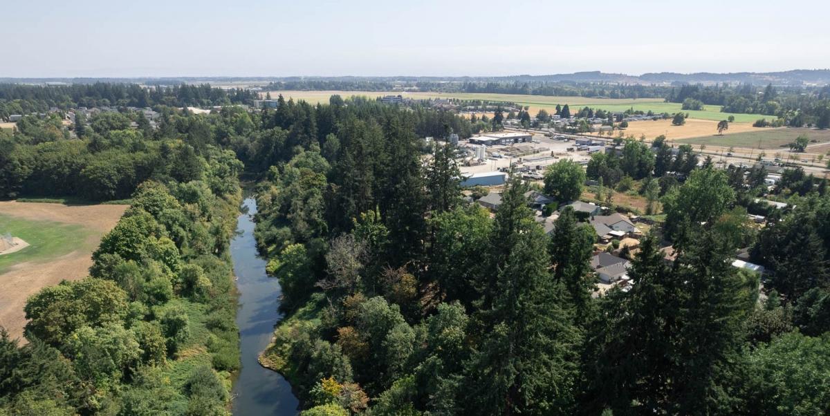
Riparian Corridor in McMinnville
In 2020, the City of McMinnville adopted Ordinance No. 5098, approving the McMinnville Growth Management and Urbanization Plan (MGMUP) 2020 UGB Update. This resulted in an expansion of the McMinnville urban growth boundary (UGB) by 662.40 gross buildable acres (862.40 gross acres) of additional land to the UGB to meet identified residential, commercial, industrial, and other public and semi-public land needs for a targeted population forecast of 44,055 people.
In the course of evaluating land for the UGB expansion, the City discovered natural hazards and natural resources in the expansion areas that needed to be studied and addressed.
The City hired Winterbrook Planning in 2021 to help with the Natural Hazards (Oregon Land Use Goal #7) and Natural Resources (Oregon Land Use Goal #5) planning work.
Data was collected and evaluated. Inventories and maps were created of the natural hazards and natural resources within the City of McMinnville’s urban growth boundary, and a report was delivered to the City of McMinnville.
- Draft McMinnville Natural Resources Program Recommendations, 2021
- Draft Comprehensive Plan Chapter XI Natural Features
- Draft Chapter 17.47 Riparian Corridor Protection Code Amendments
- Draft Chapter 17.58, Trees, Landmark and Significant Code Amendments
Below are all of the documents associated with the 2021 data collection and evaluation:
Riparian Corridors
- Inventory Report
- Appendix A - Riparian Corridor Map
- Appendix B - Index Maps
- Appendix C - Key to Scientific Names
Tree Groves
- Assessment Report
- Appendix A - Tree Grove Maps
- Appendix B - Assessment Forms
- Appendix C - Key to Scientific Names
Scenic Views
Maps
- Natural Features & Natural Hazards
- Riparian Corridor - Natural Features
- Riparian Corridor - Natural Hazards
- Tree Groves - Natural Features
- Tree Groves - Natural Features & Hazards
- Tree Groves - Natural Features & Wildfire
- Scenic Views - Natural Features
For any further questions regarding Natural Resources information, feel free to reach out to the Community Development Director, Heather Richards, directly at Heather.Richards@mcminnvilleoregon.gov
Supporting Documents
- Applications & Fees
- Code Compliance & Community Relations
- Committees & Meetings
- Community Development Center
- Community Development Department
- Economic Development
- Frequently Asked Questions - Planning
- Historic Preservation
- Uncover: McMinnville Historic Preservation
- Pioneer Hall, Linfield University, Built 1883
- Samuel Cozine House: Home of McMinnville Downtown Association
- McMinnville Public Library, Carnegie Library
- Schilling Building, (Boss Saloon), Built prior to 1884
- The Oregon Hotel, Hotel Elberton, McMenamins Oregon Hotel, Built 1905
- United Presbyterian, First Presbyterian Church, Built 1897, updated 1909
- McMinnville, Southern Pacific Train Depot, Built 1913
- Old City Powerplant, Built 1926-1927
- First Baptist Church, Built 1926
- Wright Building, Built 1893
- McMinnville City Hall, Built post 1928
- McMinnville Bank, Built 1885
- City Park, Est. 1908
- Star Mill Way, Built 1882
- Malone Cemetery
- Buchanan Cellars - Built 1888
- Mac Market - Built 1929
- Knights of Pythias Building - Built 1886
- Cooks Hotel/Mack Theater
- Linfield Observatory - Built 1894
- Grissen House - Built 1889
- Frank E Rodgers House
- 535 NE Cowls St - Built 1912
- Chinese Laundry - Dates Unknown
- Shadden House - Built 1859
- Dielschneider House 610 NE Cowls St – Built 1900
- Hodson House - Built 1895
- Masonic Building - Built 1913
- 135 NE Irvine St – Built 1895
- Newby-Cook House - Built 1879
- Uncover: McMinnville Historic Preservation
- Informational Brochures
- Long Range Planning Projects
- Planning Projects Underway
- City Initiated Projects
- Natural Hazards
- Natural Resources Protection
- G 7-24 - Update to Water System Element of Public Facility Plan
- Southwest Area Plan
- Transitional Housing (G 6-24)
- Great Neighborhood Principles
- G4-24 Housing Production Strategy (HPS)
- G 1-23 - Short-Term Rental Standards Amendment
- G 2-22 - Short-Term Rental Re-Evaluation
- G 1-22 - Fox Ridge Road Area Plan Project
- G 7-21 - Three Mile Lane Area Plan (3MLAP) Comprehensive Plan Amendment
- G 5-21 - Yamhill County Transit Area (YCTA)/Transit Development Plan (TDP)
- G 4-21 - McMinnville OR 99W Active Transportation Concept Plan
- G 3-21 - Annexation Requirements & Procedures
- G 2-21 - City Center Housing Overlay & Nonconforming Dwellings in C-3
- G 1-21 - McMinnville Municipal Code - Chapter 17
- Shaping Up: Missing Middle Housing & Residential Design Standards
- City Center Housing Strategy
- Growing McMinnville Mindfully
- Urbanization Study Phase 1: Residential Buildable Lands Inventory, Housing Needs Analysis, and Housing Strategy
- Urbanization Study Phase 2: Economic Opportunities Analysis (EOA) Update and Urbanization Report
- 2020 Comprehensive Plan Map and/or Zone Change Applications
- Americans with Disabilities Act (ADA) Transition Plan Project
- 2019 Comprehensive Plan (Goals & Policies) and/or Zoning Ordinance Text Amendments
- 2018 Comprehensive Plan (Goals & Policies) and/or Zoning Ordinance Text Amendments
- 2017 Comprehensive Plan (Goals & Policies) and/or Zoning Ordinance Text Amendments
- G 9-17 - Zoning Ordinance Amendment - Chapter 17.72
- G 8-17 - Zoning Ordinance Amendment - Chapter 17.62
- G 6-17 - Zoning Ordinance Amendments - Chapter 17.12
- G 5-17 - Comprehensive Plan Text Amendments - Chapter X (Citizen Involvement)
- G 4-17 - Zoning Ordinance Amendments - Chapter 17.55
- G 3-17 - Zoning Ordinance Amendments - Chapters 17.59, 17.65, and 17.72
- G 2-17 - Zoning Ordinance Amendments - Chapter 17.53
- G 1-17 - Zoning Ordinance Amendments - Chapters 17.57 and 17.58
- Development Projects
- Administrative Variance Applications
- Appeals
- Comprehensive Plan Map and/or Zone Change Applications
- 2025 Comprehensive Plan Map and/or Zone Change Applications
- 2024 Comprehensive Plan Map and/or Zone Change Applications
- 2022 Comprehensive Plan Map and/or Zone Change Applications
- 2021 Comprehensive Plan Map and/or Zone Change Applications
- 2020 Comprehensive Plan Map and/or Zone Change Applications
- 2019 Comprehensive Plan Map and/or Zone Change Applications
- Zone Change (ZC 4-19) and Conditional Use Permit (CU 4-19) - 1945 NW 2nd Street
- Zone Change (ZC 3-19) and Subdivision (S 2-19) - R4409DC01100
- Comprehensive Plan Amendment/Zone Change/Planned Development Amendment/Conditional Use (CPA 2-19/ZC 2-19/PDA 1-19/CU 2-19) - 1901 NW Baker Creek Road
- Comprehensive Plan Amendment/Zone Change/Planned Development/Planned Development Amendment/Subdivision/Landscape (CPA 1-19/ZC 1-19/PD 1-19/PDA 2-19/S 1-19/L 12-19) - 1755 NW Baker Creek Road
- 2018 Comprehensive Plan Map and/or Zone Change Applications
- 2017 Comprehensive Plan Map and/or Zone Change Applications
- Conditional Use Permit Applications
- Downtown Design Review/Waiver Applications
- Historic Landmarks Applications
- Gwendolyn Hotel (HL 6-22, HL 7-22, HL 8-22, and DDR 2-22) - 609, 611 and 619 NE Third Street
- Certificate of Approval for Alteration (HL 4-21) - 300, 303, 406, & 546 NE 3rd Street
- Certificate of Approval Demolition (HL 2-21) -415/423 SE College Avenue
- Certificate of Approval Demolition (HL 1-21) - 900 SW Baker Street "Mac" Hall
- 2020 Historic Landmarks Applications
- Certificate of Approval Alteration (HL 7-20) - 608 NE 3rd Street
- Certificate of Approval Demolition (HL 6-20) -826 SW Gilson Street
- Certificate of Approval Alteration (HL 5-20) - 225 NW Adams Street
- Certificate of Approval Alteration (HL 4-20) - 806 SE Davis Street
- Certificate of Approval Alteration (HL 3-20) - 835 NW Birch Street
- Certificate of Approval Demolition (HL 2-20)
- Historic Resource Inventory Amendment (HL 1-20) - 404 NE Irvine Street
- Historic Landmarks Committee Meeting
- 2019 Historic Landmarks Applications
- 2018 Historic Landmarks Applications
- Minor Partition Applications
- Minor Partition (MP 5-20) - 2185 & 2191 NW 2nd Street
- Minor Partition (MP 3-21) - 902 & 988 NW Baker Crest Court
- Minor Partition (MP 2-21) - 2755 NE Highway 99W
- Minor Partition (1-21) - 1206 NE 10th Avenue
- 2020 Minor Partition Applications
- 2019 Minor Partition Applications
- 2018 Minor Partition Applications
- 2017 Minor Partition Applications
- Minor Partition (MP 8-17) - 1301 NW Michelboook Lane
- Minor Partition (MP 7-17) - 1730 SW 2nd Street
- Minor Partition (MP 6-17) - 2880 NE Lafayette Avenue
- Minor Partition (MP 5-17) - Baker Creek East
- Minor Partition (MP 4-17) - NE Miller Street/NE Riverside Drive
- Minor Partition (MP 3-17) - 1600 NE McDonald Lane
- Minor Partition (MP 2-17) - 802 & 804 SE Davis Street
- Minor Partition (MP 1-17) - 2950 NE Hembree Street
- Planned Development/Planned Development Amendment
- 2024 Planned Development/Planned Development Amendment Applications
- 2023 Planned Development/Planned Development Amendment Applications
- 2020 Planned Development/Planned Development Amendment Applications
- 2019 Planned Development/Planned Development Amendment Applications
- 2018 Planned Development/Planned Development Amendment Applications
- Planned Development Amendment (PDA 6-18)
- Planned Development Amendment (PDA 3-18/PDA 4-18) & Subdivision (S 3-18)
- Planned Development Amendment (PDA 2-18) (Ordinance 4990) & Subdivision (S 2-18)
- Planned Development Amendment (ZC 3-18) - Ordinance 5021
- Planned Development Amendment (ZC 2-18) - Ordinance 5021
- 2017 Planned Development/Planned Development Amendment Applications
- Recent Decisions
- Subdivision Applications
- Three Mile Lane Development Review
- Variance Applications
- City Initiated Projects
- Plans & Ordinances
- RFPS
- Street Tree Guidelines
- Urban Renewal
- Zoning & Maps
Contact Information
 Community Development Director:
Heather Richards
Planning Phone: 503-434-7311
Planning Email
Community Development Department
Community Development Center
231 NE Fifth Street
McMinnville, OR 97128
Hours of Operation
Monday- Friday: 7:30am - 5:30pm
Office Lobby Hours (Walk-In Availability)
Monday- Thursday: 7:30am - 5:30pm
Fridays: Closed
Appointments are available with CDC staff.

